📍 Meet-Up Sedona, AZ meet-up - September 12 - 13, 2025

Added to Calendar: 09-13-25

Meet-Up📍

If you are planning to or considering joining this meet-up, please respond to the following poll

  • Arriving Friday evening - I might meet-up after dinner

    Votes: 0 0.0%

  • Total voters
    15
Not sure who is planning to camp vs. hotel, but if you're camping, may be good to coordinate so everyone ends up at the same camp ground. That will make it a bit easier to coordinate meeting-up / hanging out if we're a bit clustered together. I believe @speeddev and @Godzilla/Tremornator are planning to camp anyone else camping?

@AZsurveyor - any suggestions on a good campsite that's close enough to where the hotels are?
If my navigator doesnt join me, I'll probably look to tent camp. Doubt i'll have my Lone Peak by then.
 
Not sure who is planning to camp vs. hotel, but if you're camping, may be good to coordinate so everyone ends up at the same camp ground. That will make it a bit easier to coordinate meeting-up / hanging out if we're a bit clustered together. I believe @speeddev and @Godzilla/Tremornator are planning to camp anyone else camping?

@AZsurveyor - any suggestions on a good campsite that's close enough to where the hotels are?
Just behind the Hilton you're staying in, is a trailhead. I drove in here inadvertently one day, got to the trailhead and turned back around. I'm wondering if this forest road would lead to any good camp spots?

I will be up in this general area next week on some job assignments and I could swing by and have a closer look. Same goes for anyone wanting me to check out others places or areas.

I will be staying in an airBnB in Cornville which is just approximately 15 minutes south of where @DTX2023Tremor is staying. Cornville is literally a big farm and grape cultivation area (beautiful area --lots of wineries tucked in this hidden valley/creek). I've stayed in this BnB before and it was so inexpensive, it was dumb not to consider it once again. The BnB is actually in one of the farms.

I do know there are some campsites outside of Sedona, heading south to the Cornville/Cottonwood area, west of HWY 89A. This is outside of the redrock area, lying more in high desert terrain. This particuar area is once again, perhaps 10-12 minutes south of the Hiton Hotel.

Anyone have GPS Coordinates of the trailhead.

Will search for some hidden gems for public land close by
Try this:

34°51'8.98"N
111°49'52.81"W
 
Just behind the Hilton you're staying in, is a trailhead. I drove in here inadvertently one day, got to the trailhead and turned back around. I'm wondering if this forest road would lead to any good camp spots?

I will be up in this general area next week on some job assignments and I could swing by and have a closer look. Same goes for anyone wanting me to check out others places or areas.

I will be staying in an airBnB in Cornville which is just approximately 15 minutes south of where @DTX2023Tremor is staying. Cornville is literally a big farm and grape cultivation area (beautiful area --lots of wineries tucked in this hidden valley/creek). I've stayed in this BnB before and it was so inexpensive, it was dumb not to consider it once again. The BnB is actually in one of the farms.

I do know there are some campsites outside of Sedona, heading south to the Cornville/Cottonwood area, west of HWY 89A. This is outside of the redrock area, lying more in high desert terrain. This particuar area is once again, perhaps 10-12 minutes south of the Hiton Hotel.


Try this:

34°51'8.98"N
111°49'52.81"W
@AZsurveyor - Isn't that trailhead for walking only, maybe I'm missing something. I will be driving by Sedona the last week in July, I will pop over and see if I can find some open camping spots as well. If the Google Earth Searchers find something they want checked out - post up the coordinates and I will give it a look when I am there.
 
@AZsurveyor - Isn't that trailhead for walking only, maybe I'm missing something. I will be driving by Sedona the last week in July, I will pop over and see if I can find some open camping spots as well. If the Google Earth Searchers find something they want checked out - post up the coordinates and I will give it a look when I am there.
I didn't drive all the way in, pulled into the trailhead then turned back around.

I saw that the road continued on thru; perhaps it leads to nothing?

Google Earth doesn't show much either but what appears to be an open mine of some sort - this is what I want to find out.
 
Solider pass is better to hike so that can you see the sacred pools and devil's kitchen, it's a quick hike; otherwise you need a permit to take the trail and there is only a certain number of vehicles allowed per day.

I've always wanted to do Broken Arrow but it is always so busy -- what isn't full of pink jeeps and sides by sides around Sedona. The views here would be totally worth it. Maybe we could do this on Friday early morning. This trail is not long at all. It's a quick loop with plenty of obstacles along the way but from what I've been told by others, it's an easy trail.
 
Plenty of options for multiple rigs at designated dispersed camping.

I’d prefer to find one NOT marked.

Lots of options

IMG_0521.webp
 
Plenty of options for multiple rigs at designated dispersed camping.

I’d prefer to find one NOT marked.

Lots of options

View attachment 212446
That’s them, you found them.

I’m staying in the next exit south of Deer Pass called Page Springs Road.
 
Plenty of options for multiple rigs at designated dispersed camping.

I’d prefer to find one NOT marked.

Lots of options

View attachment 212446
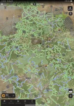
Have you seen the OnX update for dispersed camping? They have a dispersed camping overlay now in the layers section. Said the west is pretty much done, and they're moving east to finish up over the next month or so. It's very cool!
 
Have you seen the OnX update for dispersed camping? They have a dispersed camping overlay now in the layers section. Said the west is pretty much done, and they're moving east to finish up over the next month or so. It's very cool!
It’s funny you mention that. I had not noticed that until today when I used OnX. Had never heard of the term dispersed camping until Boke used it a few posts above but that doesn’t mean anything. I’m not an overlander but a wine drinker which is why I opted for the cabin in the farm, inside the grapevines. 🤣
 
Have you seen the OnX update for dispersed camping? They have a dispersed camping overlay now in the layers section. Said the west is pretty much done, and they're moving east to finish up over the next month or so. It's very cool!

IMG_0523.webp
 
I love that they added this. So much easier than trying to find the official maps on the various state and national forest websites.
 
I feel like we have to give surprise camping an shot just for the name, but who knows what we will find.
You might be in for a Surprise.

If you google drive it, this is what it looks like. High desert landscape

1748621448666.webp
 
You might be in for a Surprise.

If you google drive it, this is what it looks like. High desert landscape

View attachment 212483
thats how it looked on OnX.... that would work in a pinch....and I love a desert landscape as much as the mountains... but this is prime desert camping to me!

IMG_2766.webp
 
The other side of the highway might be a little better - there's more topography to the terrain with vegetation.
 
Hu, well clearly I'm not the one to pick the campsite... where we headed @TellurideTremor :D
Edge of the World (East Pocket)
• Offers incredible canyon views and overlooks Sedona’s famous red rock formations.
• Highly rated for scenery, but requires a vehicle with decent clearance to access

IMG_4970.webp
IMG_4967.webp
IMG_4968.webp
 
Back
Top Bottom