@Godzilla/Tremornator travel & antics

wallace is where i plan to jump on the ID BDR. You, my friend, might actually be on it.
Lemme know and i'll send you the gpx file.

leg starting tomorrow morning

working my way to "craters of the moon"

 
so I will need to figure out what to do out of Hoyt

maps bails out east to i90 or west to state highways?????

maybe there isn't any through passes in there?????

find or know of one let me know

Screenshot_20250831_201924_Maps.webp
 
Have fun and leave a bread crumb trail. I tried that many years back and eventually got to impassable trails and ended up back tracking to the highway.
remember any road names that dead ended?

i gotta be in sedona 9/10
🤣😂🤣😂🤣😂
 
remember any road names that dead ended?

i gotta be in sedona 9/10
🤣😂🤣😂🤣😂
Unfortunately not, and that may have been part if our problem. We weren't using maps, just driving south and seeing how far we could get. Ahhh, the fun days
 
Beautiful area. We were just riding dirt bikes up there earlier this month. No help with the nav situation but best of luck! At least you've got Starlink (y)

IMG_5920.webp

DJI_0117.webp
 
Highly recommend the route OmahaBravo is mentioning. I’ve ran a good portion of it south. I’m dreaming of running the entire stretch just got to decide if I’m going to do it on my bike or in my Tremor.
 
There is a BDR all the way to Sedona I'd bet. 😎
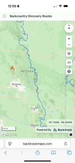
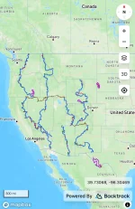
No actual BDR route to or through Sedona. The blue lines are BDR routes, and the brown dotted lines are connector routes. Red X on the Arizona BDR map is Sedona. Either way you can get close enough, and it would be way more fun that way.
 

Attachments

  • IMG_2153.webp
    IMG_2153.webp
    67.8 KB · Views: 19
  • IMG_2152.webp
    IMG_2152.webp
    141.2 KB · Views: 20
Back
Top Bottom